Published Feb 15, 2024 | 9:00 AM ⚊ Updated Feb 15, 2024 | 9:00 AM

")
There will likely be a transition from El Niño to a neutral state by April-June 2024. (Creative Commons)

Scientists say El Niño, the natural, recurrent warming of the eastern tropical Pacific Ocean, added to global warming to break the summer temperature record in 2023. The trend might continue partly into this year after the hottest January on record for land and oceans.
However, El Niño is weakening. While above-average sea surface temperatures continued across most of the equatorial Pacific Ocean, these anomalies weakened slightly in parts of the world’s largest ocean, especially below the surface near the equator, the US National Oceanic and Atmospheric Administration (NOAA) reported.
That means there will likely be a transition from El Niño to a neutral state by April-June 2024 (with a 79 percent chance), and more than half the chance of La Niña or the cooler phase developing by June-August 2024, NOAA scientists said.
Since global records began in the mid-19th century, 2023 was the warmest year. It notched 1.18 degrees C above the 20th-century average of 13.9 degrees C. Unlike 2021 and 2022 in the La Niña phase, 2023 experienced a transition to a warm El Niño phase by its second half. El Niño episodes are associated with warmer global temperatures.
During El Niño phases, the warmer waters of the eastern Pacific change atmospheric circulation patterns that influence global weather. The impacts felt across the world usually last 6–12 months.
These remote effects of ENSO are often described as teleconnections – ocean and atmosphere changes in one part of the world affecting weather events 1000s of miles away. For instance, El Niño has historically suppressed Indian summer monsoon rainfall, though not always. La Niña generally increases rain. Several severe drought events, including the 1877, 1896 and 1899 famines, had an El Niño connection.
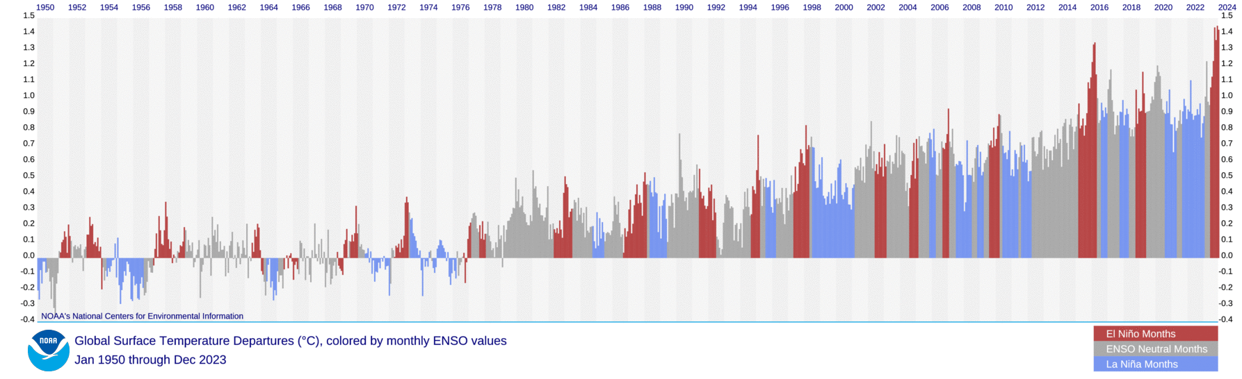
Global monthly temperature anomalies, with ENSO status. Source: NOAA
The fishers off the coast of Peru first told the world about unusually warm waters appearing on their Pacific coast around Christmas. They called the phenomenon “the little boy” in Spanish; in capitals, The Little Boy means Infant Jesus.
El Niño influences ocean and land temperatures, ocean currents, fisheries, and local weather worldwide. The event occurs in two- to seven-year irregular cycles. It is an example of climate variability due to natural or periodic air and ocean circulation changes.
El Niño is linked to trade winds blowing east to west along the equator. These winds historically helped sailors cruise their ships from European and African ports towards America and from there to Asia. They still help ship movements.
The “trades” take warm waters from South America towards Asia. That makes cold water from ocean depths move upwards in what is called upwelling. El Niño and La Niña break these patterns. Trade winds weaken during an El Niño season. Warm water is pushed back eastward towards the American west coast. This temporary warming of the ocean pushes the Pacific jet stream south, making parts of the northern US and Canada dryer and warmer. The impacts, however, are not limited to the Americas.
La Niña means Little Girl, and it reverses the effects of El Niño. Trade winds are stronger than usual and push more warm water toward Asia. Upwelling increases off the US west coast and the cold waters in the Pacific push the jet stream northward. That leads to drought in the southern US, heavy rains and flooding in the Pacific Northwest and Canada (and elsewhere), and a more pronounced hurricane season.
The trade winds gain and lose strength due to changes in the pressure gradient—the change in air pressure over a distance — over the Pacific. Waring of the sea surface expands the air over it, making it lighter and rise upwards. Lighter air lessens the atmospheric pressure. It’s a bit of a chicken-and-egg play – the pressure differential and the sea surface temperature influence each other.
Usually, the atmospheric and oceanic phenomena described above are packed in a single technical term – El Niño Southern Oscillation (ENSO). The Southern Oscillation describes a twin-peak variation in the air pressure (exerted by the air column above a place) at sea level between two specified observation stations.
It is measured in the Southern Oscillation Index (SOI), a standardised measure based on the observed sea level pressure differences between the Polynesian island of Tahiti and Darwin, Australia. It indicates the large-scale, east-west fluctuations in air pressure occurring in the western and eastern tropical Pacific during the alternating El Niño and La Niña episodes.
Climate scientists and historians have studied ENSO teleconnection in the Indian context and associated several historical events with this phenomenon of the Pacific. That’s another fascinating story.
