Published Aug 21, 2023 | 4:48 PM ⚊ Updated Aug 21, 2023 | 4:48 PM

")
Clear sky at Vettukad Beach in Thiruvananthapuram. (KA Shaji/South First)

With forecasts of a strong El Niño event, this month is becoming one of the most rain-starved Augusts on record with already a 40 percent deficit. Rains this week (20-26 August) and later may not make up this monsoon season’s overall deficit across India, scientists indicate.
The National Centre for Medium-Range Weather Forecasting outlook shows rainfall across India this week and “near normal” conditions for much of the country till mid-September. Still, there may not be enough rain, experts suggest.
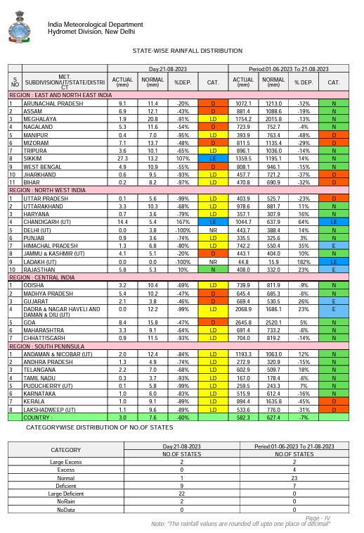
Statewise rainfall distribution.
“Models suggest monsoon is moving northward again with a weak spell over the country during 21-28 August,” said Dr Madhavan Nair Rajeevan, Ministry of Earth Sciences (MOES) Distinguished Scientist at the National Centre for Earth Science Studies, Thiruvananthapuram.
“Thus, August 2023 could be the most deficient August in history with around 40 percent deficit. In 2005, the deficit was 25 percent,” he posted on X, formerly Twitter.
There is still the possibility of rain as the southwestern monsoon lasts till September end. However, in El Niño years there has been less-than-usual rainfall in September.
Data suggest, during El Niño years, there is an 87 percent chance for the country to receive a tenth less rain than average in September, and about half (47 percent) the chance of getting a fifth less, Rajeevan explained.
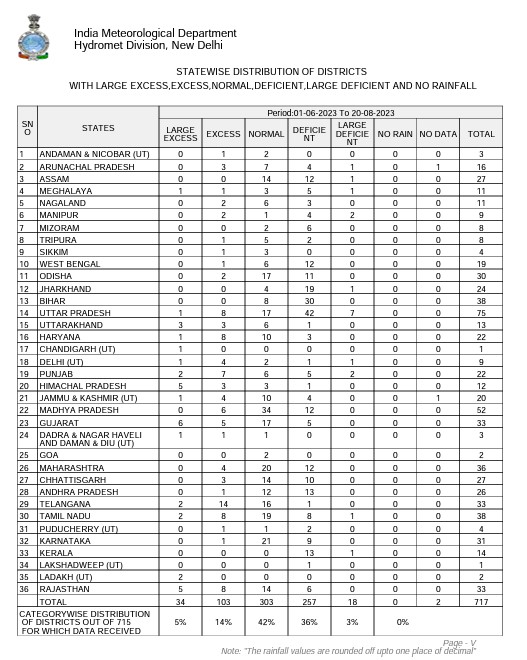
Statewise distribution of districts.
US National Weather Centre’s Climate Prediction Center forecasters said they were confident about a “strong” El Niño event that would continue through winter, with global impacts like rainfall changes and then a warmer-than-usual summer.
El Niño denotes a large-scale ocean-atmosphere climate phenomenon linked to periodic warming in sea-surface temperatures across the central and east-central equatorial Pacific.
El Niño represents the warm phase and La Nina the cold phase of the El Niño/Southern Oscillation (ENSO) cycle that also involves related changes in atmospheric conditions. El Niño induces drier conditions through the Caribbean, Indonesia, and India. Historically it has been associated with droughts in India.
US Climate Prediction Center noted: “El Niño is anticipated to continue through the Northern Hemisphere winter, with greater than 95 percent chance through December 2023-February 2024.”
The US forecasters said that El Niño conditions prevailed in July, with above-average sea surface temperatures across the equatorial Pacific Ocean.
They forecast roughly two in three odds of an event reaching sea surface temperatures exceeding 1.5 degree Celsius for the November-January seasonal average in a Pacific Ocean area called Niño 3.4.
Clear sky in Thiruvananthapuram on 21 August. (KA Shaji/South First)
Conditions there represent the average equatorial sea surface temperatures across the Pacific from about the dateline to the South American coast. An increase of 0.5 degree Celsius or higher at Niño 3.4 is considered an El Niño condition.
El Niño has a strong influence over the Indian monsoon, scientists note. When an El Niño warms up the tropical Pacific upper atmosphere, it pumps more air toward the poles. The changes in the atmospheric circulation translate as ground-level weather impacts across the globe.
Scientists, however, note that a strong El Niño does not necessarily lead to strong impacts in different localities.
Meanwhile, India Meteorological Department has acknowledged that weak monsoon conditions prevailed over most parts of India.
The southern peninsula and the country as a whole received less than half the usual rain during the week of 10-16 August.
All 14 districts in Kerala have received deficient rains throughout the season. Kerala has received 45 percent less rain than normal this season so far. Half of the 26 districts in Andhra Pradesh have also received deficient rain.
In Kerala, temperatures have started rising, with the Integrated Rural Technology Centre at Palakkad recording 32.3 degrees Celsius on Saturday. The average for August and September in years with normal rainfall is under 28 degrees Celsius.
Two of the four-month Southwest monsoon season are over, and with the rain deficit at a high, experts are predicting a four-month drought.
This contradicts the earlier forecast of above-normal rainfall issued by the India Meteorological Department (IMD) for the southern peninsula.
The experts at the Kottayam-based Institute of Climate Change Studies (ICCS), which takes stock of the performance of the monsoon, said the remaining days in August are unlikely to witness any extreme rainfall events as in the past few years.
From 1 June to 16 August, Kerala received only 877.2 mm of rainfall, whereas normal rainfall figures recorded for the Southwest Monsoon in the state are 1,572.1 mm, according to the IMD.
This translates to a deficit of more than 44 percent this season.
Rainfall data for the seven days — from 10 to 16 August — illustrate the acute situation. There has been a 94 percent deficit during that period, as the rainfall recorded was a mere 6.5 mm compared to normal rainfall of 109.6 mm.
