
Published Sep 01, 2023 | 10:00 AM ⚊ Updated Sep 01, 2023 | 10:00 AM


Erra Matti Dibbalu near Visakhapatnam. (Supplied)

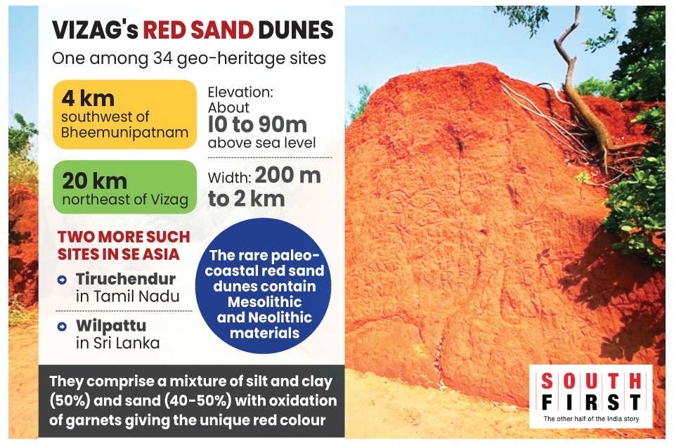
The undulating terrain comes as a surprise on the Beach Road, some 20 km from Visakhapatnam. The Erra Matti Dibbalu (EMD) — red sand dunes — stand testimony to geographical changes that they underwent over millions of years.
The greenery along the ridges paints a contrasting picture to the red surroundings, capturing nature’s magnificence in a wide frame, about five-km long. The stillness of the breathtaking view is also a reminder of a promise made more than nine years ago, a promise that seems to have been stuck in a time warp.
The Geological Survey of India (GSI) had, on 19 July, 2014, resolved “to recognise and declare Erra Matti Dibbalu — the dissected and stabilised coastal red sediment mounds/dunes forming characteristic badlands located between Visakhapatnam and Bheemunipatnam in Andhra Pradesh — as a Geo-heritage Site”.
The EMD, which looks like a labyrinth straight out of Wild West movies, is one among 34 notified National Geological Heritage Monument sites in the country.
Several geological experts, like Dr D Rajasekhar Reddy, advisor to the Indian National Trust for Art and Cultural Heritage (INTACH)’s national geo-heritage cell, had pointed out that the scenic red sand dunes on the Vizag-Bheemili Beach Road were formed around 12,000 years ago.
According to several studies, the EMD is geologically important as it represent the late quaternary geological history showing the imprints of sea-level fall (LGM – Last Glacial Maxima) and subsequent rise, impact of climate, monsoon and geological processes in the sediments. The EMD is also scientifically rare paleo-coastal red sand dunes.
“With land prices surging on the Beach Road, a lot of real estate activities are taking place around the red sand dunes which will have an overall impact on this ecologically sensitive geo-heritage site in the long run,” environmental activist and columnist Ganjivarapu Srinivas told South First.
“No one knows who is responsible for the protection of this site. Except for a watch tower I don’t see any concrete protection measures,” he said, while noting the area’s tourism potential.
“There is no clear demarcation or fencing around such a sensitive site. The government should take up the responsibility, clearly demarcate the boundaries, put up a fence, and declare a buffer zone restricting any construction activity. Otherwise we would soon lose such an important, significant geologically sensitive site,” he added.
Though first reported over a century ago as “badlands” representing great sand banks or as isolated banks around the then buried hills, the EMD did not attract the attention of scientists until the mid-20th century.
Thereafter, the dunes remained in the focus of earth scientists, including geologists, geomorphologists, and sedimentologists, as well as archaeologists and historians.
Many studies that were carried out in the area concluded that the red sediments are in fact made of a sequence of yellow (oldest), reddish brown, brick red and light yellow (youngest) sediments that vary in size and at places contain calcrete and siliceous concretions.
While the protection of these ecologically sensitive dunes has been a matter of concern, the GSI notification sparked a debate.
Former Union government secretary EAS Sarma pointed out that EMD is a part of a unique stretch of red ravines adjacent to the Bay of Bengal coast close to Visakhapatnam city. Originally, it extended over thousands of acres but the Indian Navy took over a part of the dunes. What is left today is in excess of 2,000 acres.
“Erra Matti Dibbalu not only constitutes a unique geological site but also has been found to have highly valuable pre-historic archaeological evidence. There is published research literature on the subject. The entire stretch of the EMD has been classified as ‘red ravines’ in the village revenue records of the Andhra Pradesh government,” Sarma said in a letter to authorities.
“The Google Earth image clearly shows the terrain filled with ravines extending along a stream that drains into the sea. Parts of the EMD fall within Coastal Regulatory Zone (CRZ)-I and CRZ-III,” the former bureaucrat said.
Following GSI’s resolution, the state government, in July 2016, issued orders notifying 262 acres of the EMD as a geo-heritage site. Environmentalists have been claiming that the dunes are spread over another few hundreds of acres. Though they have raised the issue, the government has not responded so far.
Based on the map prepared by the district administration in 2015 as part of the process of notifying the site, INTACH’s Rajasekhar Reddy wrote a letter to the then district collector on 20 November, 2015, pointing out the need to expand the protected area, and explaining its significance.
The GSI resolution mentioned only the latitude and longitude coordinates of EMD without offering any clear idea about its extent.
“Even otherwise, the EMD, being partially located within CRZ-I and CRZ-III, calls for protection under the Environment (Protection) Act (EPA) and the CRZ notification. Additionally, since it also has invaluable pre-historic archaeological evidence, it attracts the provisions of the Ancient Monuments and Archaeological Sites and Remains Act, 1958,” Sarma added.
He further said that no survey has been conducted to determine the expanse of the dunes.
“The Visakhapatnam Urban Development Authority had attempted to map the EMD and its approved sketch map, showed an extent of more than 1,700 acres. It appears that the coordinates indicated in GSI’s notification (17degrees 51′ 56” and 17 degrees 52’46” latitude, 83 degrees 24′ 29” and 86 degrees 26′ 39” longitude) and the area indicated have not included the entire geological feature as visible on Google Earth. These ravines constitute a complex network, often difficult to access. It could be the reason that neither the GSI nor the local revenue authorities could accurately demarcate its boundaries,” Sarma said.
He demanded that the Union and state authorities should recognise the entire stretch visible on Google Earth as part of the EMD, calibrate it with the ground reality, and fully notify it as a stretch that should be protected under the EPA, the CRZ notification and the Ancient Monuments and Archaeological Sites and Remains Act, of 1958.
Sarma also said that, according to some reports, parts of the EMD are being included by the state government in a “land pooling” scheme for undertaking construction activity.
Heavy equipment can be seen within the natural EMD stretch, levelling the dunes, and causing irreversible damage to the unique geological feature. Sand contractors supported by political leaders are also active in quarrying sand from the heart of the EMD.
All these illegal activities amount to breach of public trust and they should stopped immediately, he added.
The earth here comprises a mixture of silt and clay (50 percent) and sand (40-50 percent) with oxidation of garnets giving it its unique red colour.
