

Published Jul 31, 2026 | 11:00 AM ⚊ Updated Jul 31, 2026 | 11:00 AM

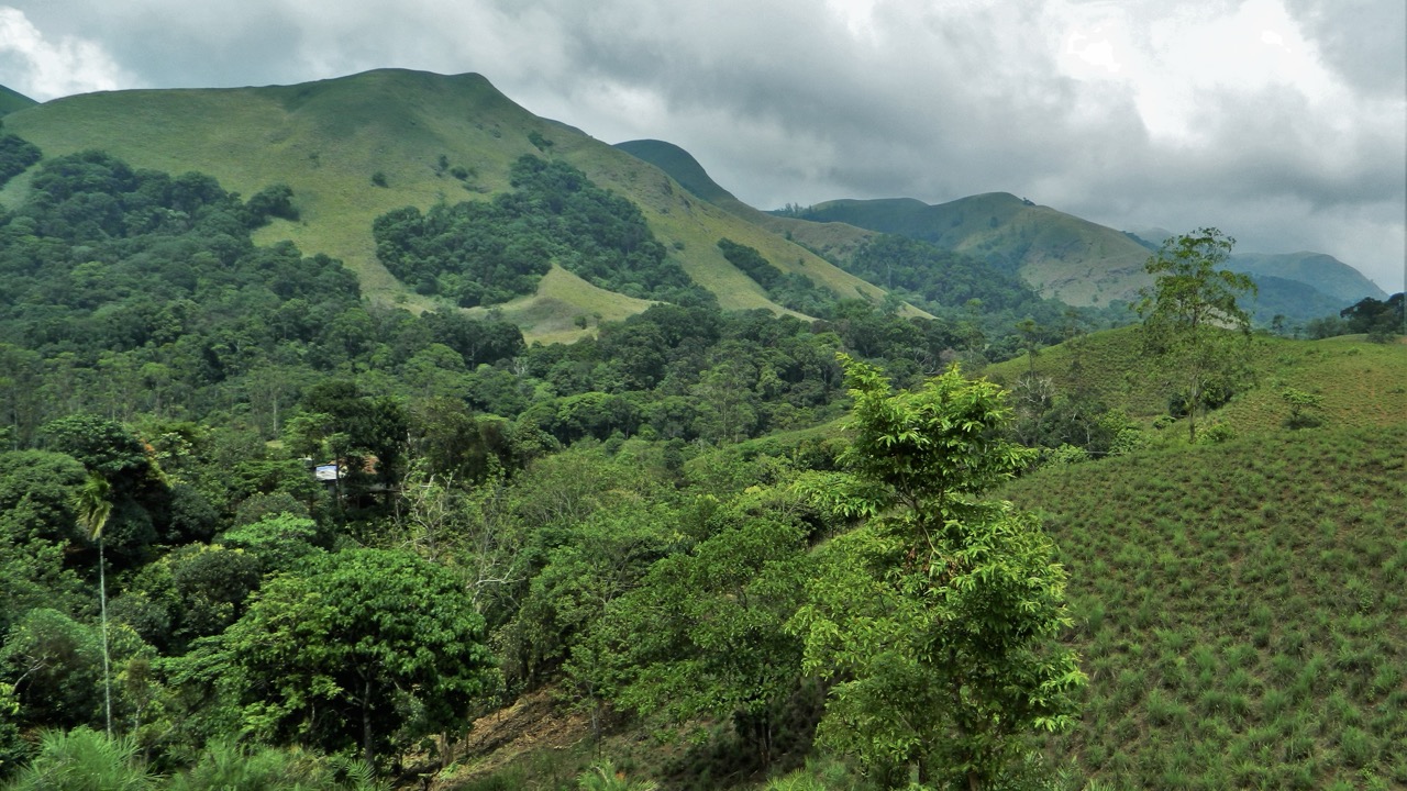
The Western Ghats stretch 1,600 km along the west coast of India, covering an area of 160,000 sq km.

Synopsis: The Centre’s latest Western Ghats ESA draft attempts to resolve long-standing disputes by revising boundaries, incorporating state-level verification and introducing a new monitoring framework. However, key concerns remain unresolved, including how restrictions will be enforced across a region inhabited by nearly 50 million people, how development will be balanced with conservation, and whether the framework adequately addresses the growing risks of landslides and climate change, particularly in Kerala. While the draft refines implementation, it stops short of resolving the core conflict between ecological protection and the livelihood concerns of communities across the Western Ghats.
After more than a decade of consultations, negotiations and political disagreements with six states, the Union Ministry of Environment, Forest and Climate Change has issued a fresh draft notification proposing the designation of parts of the Western Ghats as an Ecologically Sensitive Area (ESA). The draft is now open for public comments.
The proposal seeks to protect a 56,825.7 sq km stretch across Gujarat, Maharashtra, Goa, Karnataka, Kerala and Tamil Nadu.
The proposed area is smaller than the 59,940 sq km identified as ecologically sensitive by the K Kasturirangan committee, which recommended bringing around 37 percent of the Western Ghats’ natural landscape under protection.
The latest draft is significant not merely because of the restrictions it proposes, but because it attempts to address several issues that have delayed the notification since 2013.
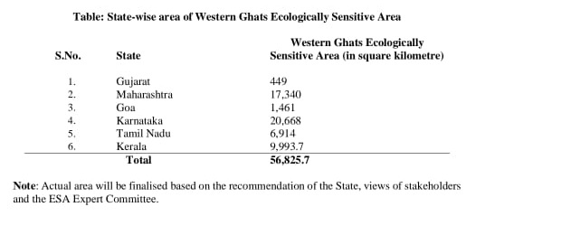
Land area proposed under the ESA by state.
It incorporates state-level physical verification of boundaries, acknowledges discrepancies in village names and mapped areas, introduces more detailed technical conditions for hydropower projects, and proposes a dedicated Western Ghats Decision Support and Monitoring Centre.
However, the draft also leaves several questions unresolved, particularly over how its restrictions will be implemented across a region inhabited by nearly 50 million people and how development projects will be assessed in a landscape already facing increasing landslide and climate-related risks, especially in Kerala.
Also Read: Kerala steps up surveillance after 56-year-old dies of H1N1
One of the most politically sensitive aspects of the draft notification is the difference between the area originally recommended and the area now proposed. The High-Level Working Group, chaired by K Kasturirangan, had earlier recommended designating 13,108 sq km in Kerala as an Ecologically Sensitive Area (ESA).
Following physical verification and consultations, the Kerala government proposed an ESA covering 9,993.7 sq km, including 9,107 sq km of forest land and 886.7 sq km of non-forest land. The Centre has retained this figure in the latest draft notification.
Across the six Western Ghats states, Karnataka has the largest proposed ESA at 20,668 sq km, followed by Maharashtra at 17,340 sq km, Kerala at 9,993.7 sq km, Tamil Nadu at 6,914 sq km, Goa at 1,461 sq km and Gujarat at 449 sq km.
However, the draft notification makes it clear that the final extent of the ESA will be determined after considering recommendations from the respective state governments.
Speaking to South First, Chris Jacob, an environmental engineer based in Kottayam, said state-level recommendations would be crucial in determining the final boundaries, particularly given the significant variations in weather and rainfall patterns across Kerala.
“Localised impact studies and recommendations are necessary, especially as Kerala is witnessing changes in the pattern of local calamities. Idukki, Wayanad and Palakkad, for instance, have distinct weather and rainfall patterns, with variations even between villages. Localised data collection is therefore essential.
“At the same time, the draft does not fully explain how differences in the scientific criteria used by the Centre and the states could affect ecological continuity across state borders,” he said.
The draft proposes a complete ban on mining, quarrying and sand mining within the ESA. Existing mines would have to close within five years of the final notification or when their current leases expire, whichever comes first.
No new thermal power plants, or expansions of existing ones, would be allowed.
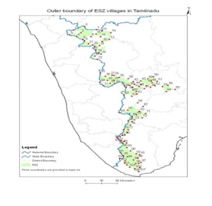
Tamil Nadu ESA villages
New ‘Red’ category industries and expansions of existing ones would also be prohibited.
However, existing Red category industries, including healthcare facilities, can continue operating under existing laws. Large construction projects would also face restrictions. New or expanded buildings with a built-up area of 20,000 sq m or more would be prohibited. Township and area development projects covering 50 hectares or more, or with a built-up area of 1.5 lakh sq m or more, would also not be allowed.
At the same time, the draft seeks to protect ordinary life within the ESA.
Existing houses can be repaired, renovated or expanded in accordance with existing laws. Property ownership will not be affected, existing healthcare facilities can continue operating, and new Primary Health Centres can be established.
Speaking to South First, Vishnu Haridas, a Muthanga native, said: “No one opposes protecting the Western Ghats, but the decisions of Karnataka and Tamil Nadu will also have a major impact. People in tiger reserve areas already struggle with forest laws, while tribal voices often go unheard. The bigger challenge will be enforcement, as land-use patterns and political priorities vary across states. Without hearing people’s voices, effective implementation will be difficult.”
Also Read: How an Assam woman’s escape led police to an alleged infant trafficking syndicate in Kerala
New hydropower projects can still be considered under the Environmental Impact Assessment (EIA) process, but they will have to meet three key conditions.
First, at least 30 percent of the river’s flow during the lean season must be maintained as ecological flow.
Second, cumulative impact studies will be required to assess how multiple projects together could affect river flows, forests and biodiversity.
Third, there must be a minimum gap of three kilometres between hydropower projects, and no more than 50 percent of a river basin can be affected by such projects.
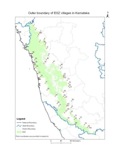
Karnataka ESA villages
This could be one of the most significant changes in the draft because it considers the combined impact of multiple hydropower projects, rather than assessing each one in isolation. In river systems with several dams, individual environmental clearances may not fully capture the cumulative impact on downstream water flows and ecosystems.
However, the 30 percent ecological-flow requirement raises some questions. The draft states that it will apply until project-specific baselines are established, but it does not clearly explain how these baselines will be scientifically calculated, who will determine them, or how long the process will take.
This creates the possibility that the temporary 30 percent standard could eventually become the permanent benchmark.
There are also questions about the three-kilometre distance rule and the 50 percent river-basin limit.
The draft does not clearly define how a river basin will be measured, whether existing hydropower projects will be included in the 50 percent limit, or how the cumulative impact of projects located outside the ESA boundary will be assessed.
Also Read: How CPI(M) lost Kerala: Inside the party’s account of its electoral collapse
The draft proposes establishing a Western Ghats Decision Support and Monitoring Centre, to be set up by the Centre in collaboration with all six states. The proposed centre will regularly assess the ecological health of the Western Ghats, support scientific decision-making and help strengthen enforcement. Projects that receive environmental or forest clearance will be monitored at least once a year by the Centre’s regional offices.
State Pollution Control Boards will separately monitor projects covered under pollution control laws.
Each of the six states will also have to prepare an annual ‘State of Health Report’ on the Western Ghats within its jurisdiction and make it publicly available.
The draft also proposes involving local communities in decision-making and monitoring.
However, while the Centre proposes a common scientific monitoring framework, enforcement will largely remain the responsibility of the states.
The draft also seeks to address concerns among residents that ESA status could lead to displacement or affect farming and plantation activities. It clearly states that property ownership will not be affected.
It also requires compliance with the Forest Rights Act and makes Gram Sabha consent mandatory for projects and activities covered under the relevant provisions.
The Centre says the aim is to balance conservation with sustainable and inclusive development. However, an important question remains: while routine farming and existing settlements are not directly prohibited, what development options will be available to villages that continue to grow within the ESA?
The draft restricts large construction projects, mining and polluting industries, but does not provide a detailed alternative development model for ESA villages. It is unfair to expect people living in the high ranges to shoulder the burden of protecting the Western Ghats while the rest of society continues to pursue unchecked development.



