Published May 02, 2026 | 7:00 AM ⚊ Updated May 02, 2026 | 7:00 AM


While a total of 143 concept notes were received from engineering institutions in the state, 46 concepts were shortlisted for final exhibition.

Synopsis: Students from across Karnataka showcased AI- and GIS-based solutions to Bengaluru’s worsening urban problems, including potholes, polluted lakes and flooding, at the state-level K-GIS exhibition held on 29 and 30 April. Projects ranged from citizen reporting platforms and lake-monitoring drones to biodiversity tracking systems and disaster response tools using real-time data and satellite inputs.
Potholes, vanishing lakes, climate change and chronic flooding… Bengaluru’s urban challenges took centre stage this week as students from universities across the state gathered at the Karnataka State Remote Sensing Application Centre (KSRSAC) to showcase their tech- and AI-driven solutions.
The displays were organised during the Karnataka Geographic Information System (K-GIS) two-day state-level exhibition and student innovation model competition on the theme “Technologies for Managing Planet Earth”, held on 29 and 30 April.
K-GIS 2.0 builds on Karnataka’s push to integrate spatial data, digital platforms and emerging tools such as GeoAI and drones into planning and development.
While a total of 143 concept notes were received from engineering institutions in the state, 46 concepts were shortlisted for final exhibition and model demonstration during the event after a rigorous screening process by expert jury members.
Also Read: ‘Historic’ for whom? Why Karnataka’s nomadic communities are opposing new internal quota matrix
Students from CMR University in Bengaluru developed a model to give citizens control over ensuring their elected representatives are held accountable.
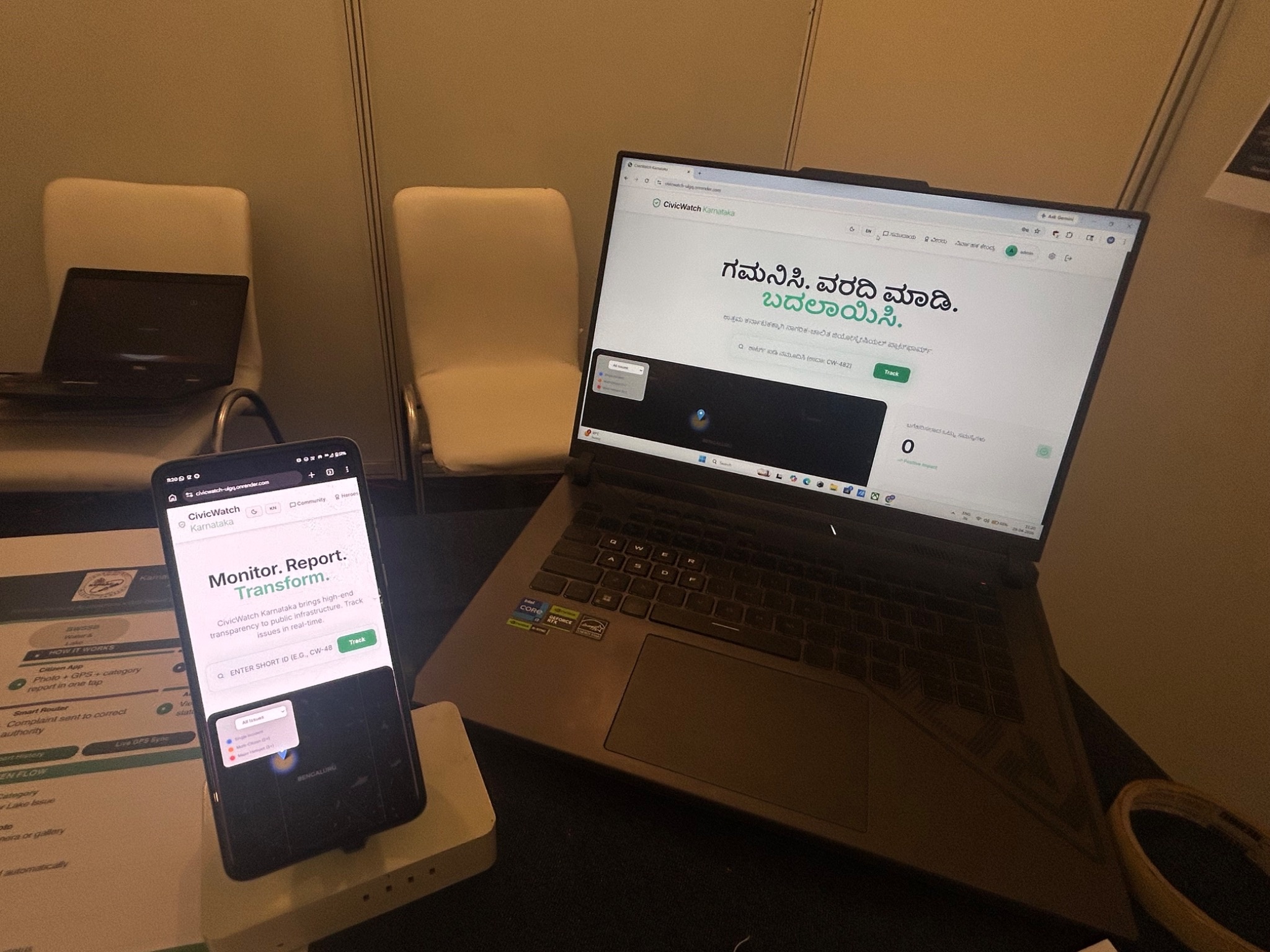
CivicWatch allows citizens to bring potholes and contaminated lakes to the administration’s attention.
The platform, called CivicWatch, allows citizens to capture photos of potholes and contaminated lakes, and upload them onto the dashboard along with the location.
The complaint will be assigned to the relevant department within the government. Citizens can then see the progress of the complaint, whether action has been taken by the concerned official and once it has been resolved.
The dashboard also uses GIS-based hotspot mapping to identify clusters across the city where recurring issues are being reported.
The idea comes against a troubling backdrop. For the fourth year in a row, Bengaluru in 2025 topped the list of reported deaths caused due to negligence by civic agencies, according to a recent report by the National Crime Records Bureau (NCRB). Several deaths have been reported due to the poor condition of roads, including potholes.
Student presenters said that the model will help ensure transparent communication between citizens and civic agencies.
Also Read: From janivara to hijab: Two dress code rows, two different outcomes in Karnataka
Another project, by students from APS College of Engineering, tackled the degradation of Bengaluru’s lakes, many of which have suffered from encroachment, pollution and neglect.
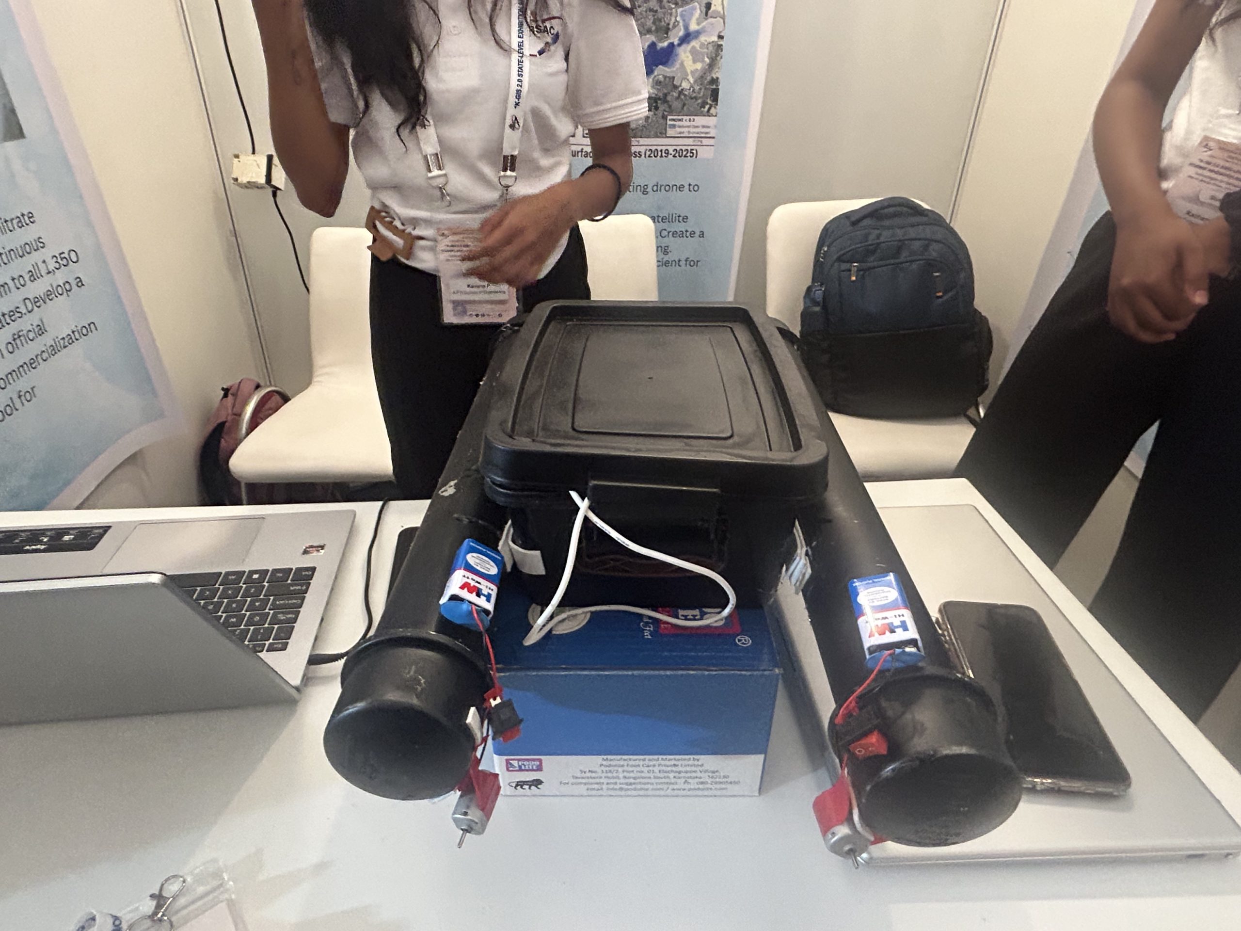
A lightweight floating drone to monitor depth, siltation, and overall lake health.
Their solution is a lightweight floating drone that measures lake depth to calculate a siltation index, indicating sediment build-up over time.
This real-time, on-ground data is combined with satellite-derived Modified Normalized Difference Water Index (MNDWI) inputs through a “satellite fusion” approach.
The integrated data is transmitted to a ThingSpeak dashboard, enabling real-time monitoring of depth, siltation and overall lake health.
Students estimate that their prototype can survey a lake in under 10 minutes, significantly reducing the need for expensive equipment. Early detection of siltation and pollution, they say, could cut restoration costs by up to tenfold.
Also Read: Karnataka to drop sugar disclosure on beer labels; brewers relieved, health experts wary
With Bengaluru’s green cover steadily shrinking, students from Cambridge Institute of Technology focused on biodiversity monitoring.
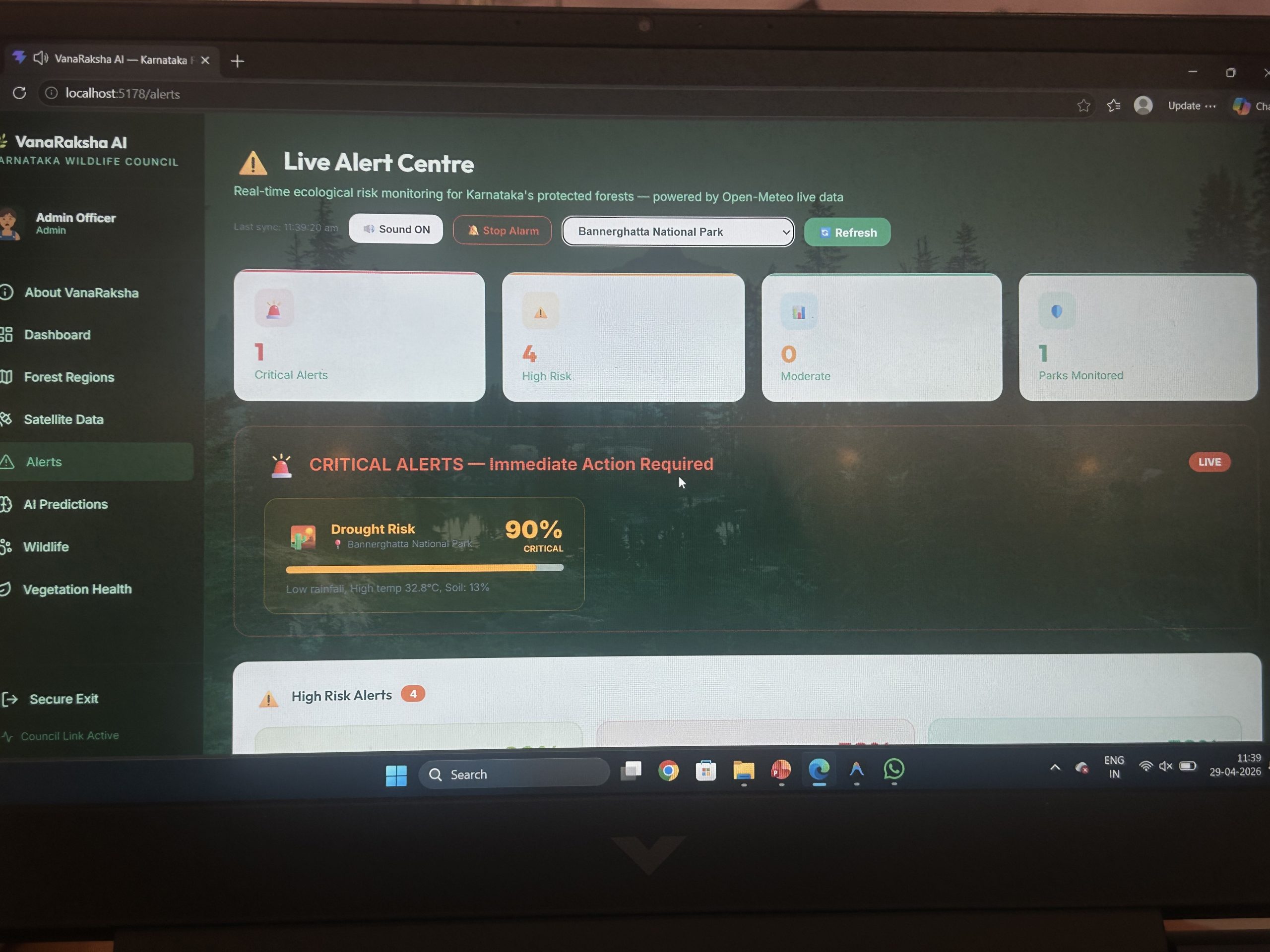
A wildlife tracker using AI object-detection system.
Their AI-driven model uses satellite data to compute the Normalised Difference Vegetation Index (NDVI), a key indicator of vegetation health.
Layered onto this is an AI object-detection system based on YOLO (You Only Look Once), which identifies and tracks wildlife in the area. The results, ranging from vegetation density to wildlife presence, are displayed on an interactive dashboard, offering near real-time ecological insights.
Students pointed out that traditional biodiversity assessments are conducted only once every few years, leaving planners without timely data in a city where ecosystems are rapidly changing.
To address Bengaluru’s increasing vulnerability to extreme weather, students from BNS College of Engineering developed FlashRescue, an AI-powered disaster intelligence and evacuation platform.
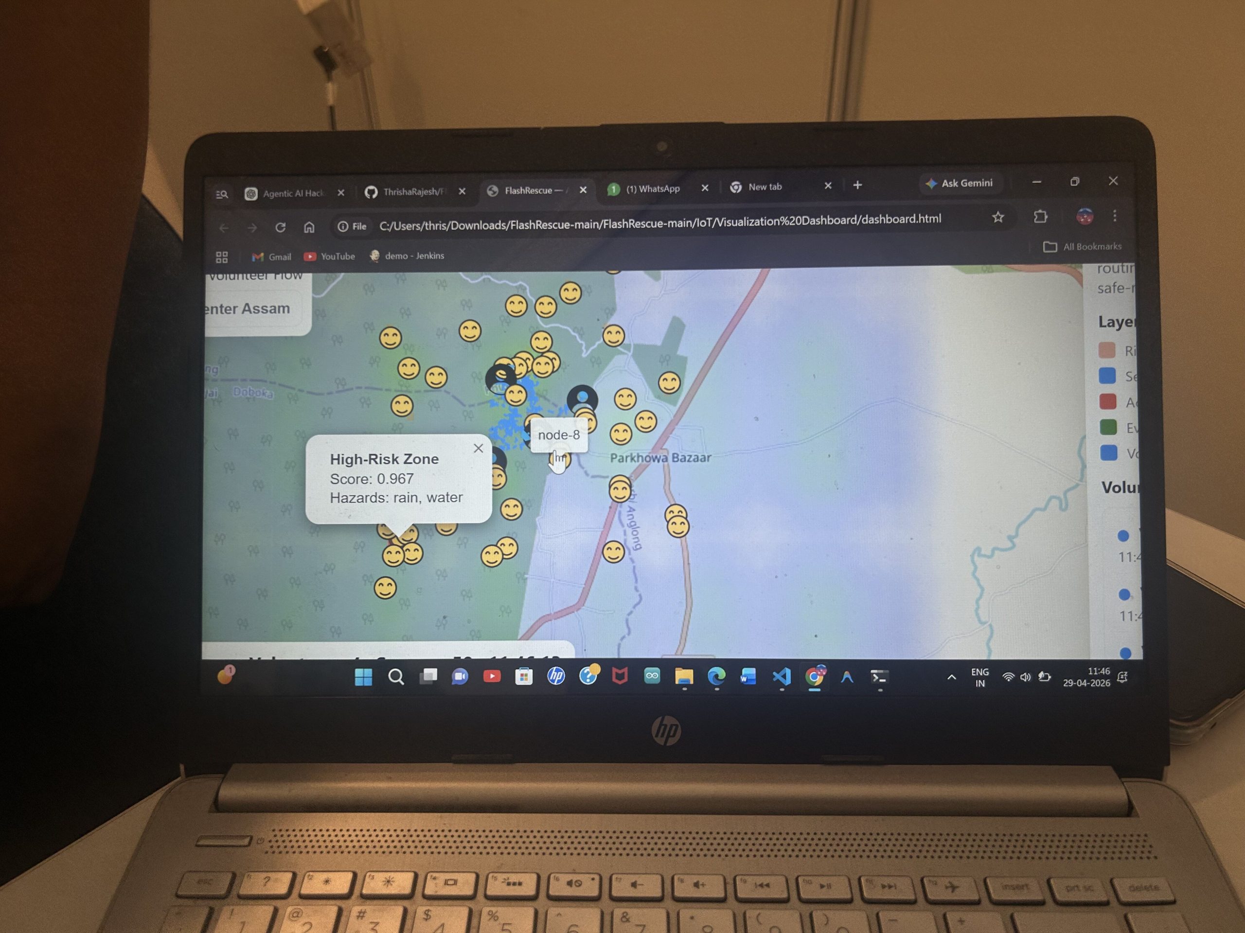
AI-powered disaster intelligence and evacuation platform.
The system integrates citizen reports, IoT sensor data such as rainfall and water levels, and satellite imagery to create a real-time “digital twin” of the city during emergencies.
AI models verify incoming data, filter misinformation and predict how hazards such as floods or fires may evolve. Based on this, the platform dynamically assigns tasks to responders and generates adaptive evacuation routes.
A live dashboard allows authorities to track incidents, resources and risk zones in real time, potentially transforming how cities respond to crises.
Similarly, students from CMR Institute of Technology presented Project Drishti, a geospatial platform aimed at climate-resilient urban planning.
It specifically focuses on challenges such as urban flooding, heatwaves and unplanned growth. By analysing datasets from government sources, the system maps flood-prone areas, identifies urban heat islands and highlights infrastructure gaps.
It plans to provide data-driven insights through a visual platform to urban planners and government authorities in a bid to promote sustainable urban development.
