Published Jul 28, 2023 | 1:00 PM ⚊ Updated Jul 28, 2023 | 1:00 PM

")
The clouds over South India as of 27 July. (IMD)

After an active spell with intense rains and flooding in different parts of South India, the Southwest Monsoon is entering a weak phase which will see reduced rainfall from this week.
“After a long, active spell, the monsoon is entering into a weak/break phase during the next 2–3 weeks with classic break-like features,” said Madhavan Nair Rajeevan, distinguished scientist at the National Centre for Earth Science Studies, Thiruvananthapuram.
“This break is inevitable after an active phase for almost one month thanks to MJO and MISO,” Rajeevan said on X (Twitter) on Wednesday, 26 July.
Madden-Julian Oscillation (MJO) is a weather system involving clouds, rainfall, winds, and pressure that traverses the tropics, influencing the monsoon.
As such rainfall varies considerably at different timescales, from daily to multi-decadal. These fluctuations in tropical rainfall often go through a 30-60-day cycle called Monsoon Intraseasonal Oscillations (MISO).
They naturally occur in the coupled ocean-atmosphere system, influencing the weather throughout the global tropics.
The tropics are the warm and rainy area on either side of the Equator (0-degree latitude) between the tropic of Cancer and the tropic of Capricorn located roughly at 23.5 degrees North and South latitudes, respectively.
Intraseasonal oscillations are often connected to the phase of the “ENSO cycle”, scientists explained.
Overall, there tends to be weak or absent MJO activity during moderate or strong El Niño episodes, as it is happening now.
El Niño (translated as a small boy in Spanish) involves surface warming of the central and eastern tropical Pacific Ocean. Alternating with a cool phase called La Niña (translated as small girl in Spanish), and together with Southern Oscillation denoting the large-scale fluctuations in air pressure between the western and eastern tropical Pacific they cause, El Niño/La Niña Southern Oscillation (ENSO).
ENSO influences global weather.
“Looks like rain is going to reduce from today. No signal of next active spell,” said Abhilash Sukumarapillai, director of the Advanced Centre for Atmospheric Radar Research (ACARR) at Cochin University of Science and Technology in Kerala.
“There will be a short break till the MJO enters the Indian Ocean region by next week… let’s see whether it produces some active spells for 2–3 days. If not it is going to be a long break,” Sukumarapillai said. “It is not limited to El Niño alone; the Indian Ocean is also playing a role.”
According to Rajeevan, it is usual to have breaks in August.
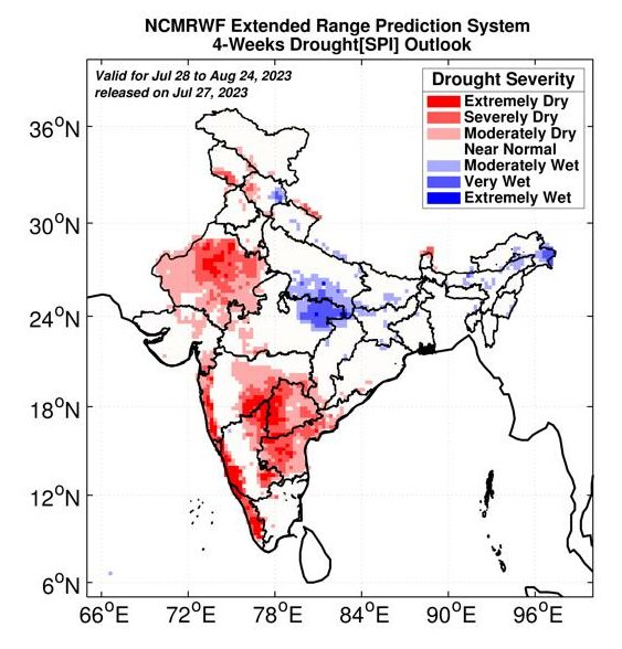 National Centre for Medium-Range Weather Forecasting under the Ministry of Earth Sciences has forecast dry conditions for much of South India except Tamil Nadu and interior Karnataka for the coming four weeks in its July 27 update. Parts of coastal Karnataka and Kerala are expected to be extremely dry.
These drought charts are updated for four weeks every Thursday, using the advanced NCMRWF extended range prediction system. Scientists consider the first two week’s prediction very good.
Monsoonal rainfall is increasingly showing fluctuations in the duration, intensity and frequency of heavy rainfall (wet spells) and low rainfall (dry spells) periods with frequent extremes such as floods and droughts, scientists note. Some of these changes are due to climate change, though all variability cannot be attributed to it.
These fluctuations have raised concern, especially about their effects on farming.
Meanwhile, El Niño is getting more prominent in the Pacific.
“The chance that our young El Niño will continue through the winter is greater than 90 percent,” wrote Emily Becker in the US National Atmospheric and Oceanic Administration ENSO blog.
The primary metric for El Niño showed it was 0.8 °C above the long-term (1991–2020) average in June, “comfortably above” the El Niño “threshold of 0.5 °C”, Becker wrote.
“El Niño is taking place in the context of a very warm global ocean, and we don’t know how the warm globe will affect El Niño’s atmospheric conditions,” she added.
El Niño is the most predominant factor influencing the monsoon, Rajeevan explained.
Historically, June-August dryness and droughts have been reported in India during El Niño years. IMD, however, has assured that the effects of the Indian Ocean Dipole will nullify the effects of El Niño.
The Indian Ocean Dipole (IOD) denotes the difference in sea surface temperature between two areas (poles) in the western and eastern Indian Ocean.
It affects the climate of Australia and other countries that surround the Indian Ocean Basin, and it contributes to regional rainfall variability. While ENSO forecasts are considered very good, prediction of IOD from the models is not perfect, scientists note.
