Published May 18, 2023 | 9:00 AM ⚊ Updated May 18, 2023 | 9:00 AM

")
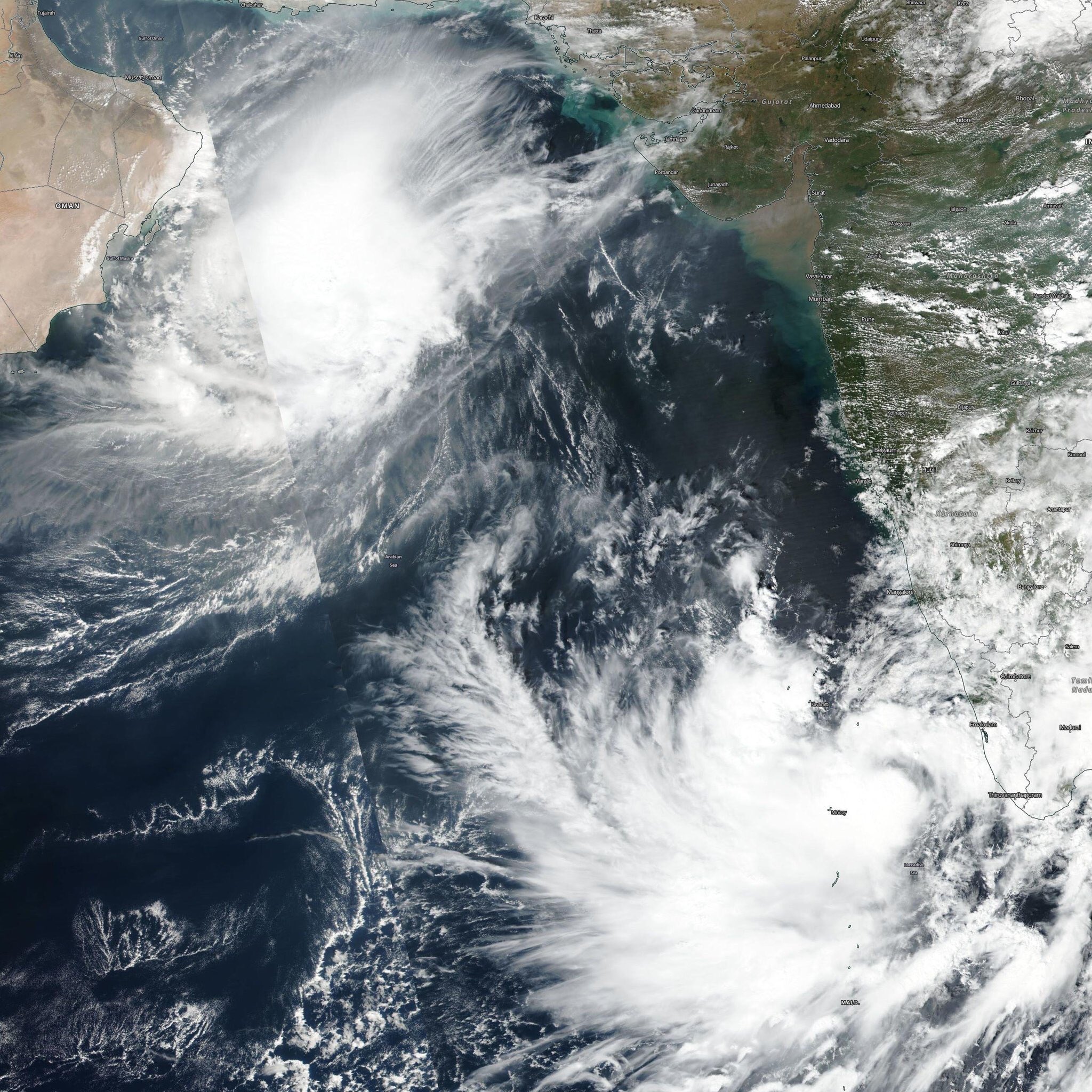
Satellite view of cyclone Mocha. (NASA)

Cyclone Mocha tore through the coastlines of Bangladesh and Myanmar on Sunday, 14 May, marking an increase in the frequency of extremely severe (winds above 168 kmph) and even greater cyclonic storms in the North Indian Ocean (NIO).
According to experts, intensifying storms pose serious threats in terms of disaster preparedness and humanitarian action on its coasts, including in South India.
Reportedly the storm pummelled through Myanmar at about 209 kmph. Earlier, it had attained a speed of 282 kmph, making it one of the two most powerful storms in the NIO.
It destroyed camps, homes, and infrastructure.
There are reports of numerous casualties with an official report of more than 81 deaths. However, unverified reports suggest that around 400 people lost their lives in Myanmar.
“Forecasts and disaster preparedness appear to have averted what would have been a catastrophe in terms of human suffering,” said Abhilash Sukumarapillai, director of Advanced Centre for Atmospheric Radar Research (ACARR), Cochin University of Science and Technology (CUSAT).
“In the regional and Indian contexts, forecasts are improving a lot. IMD forecast has been perfect this time.”
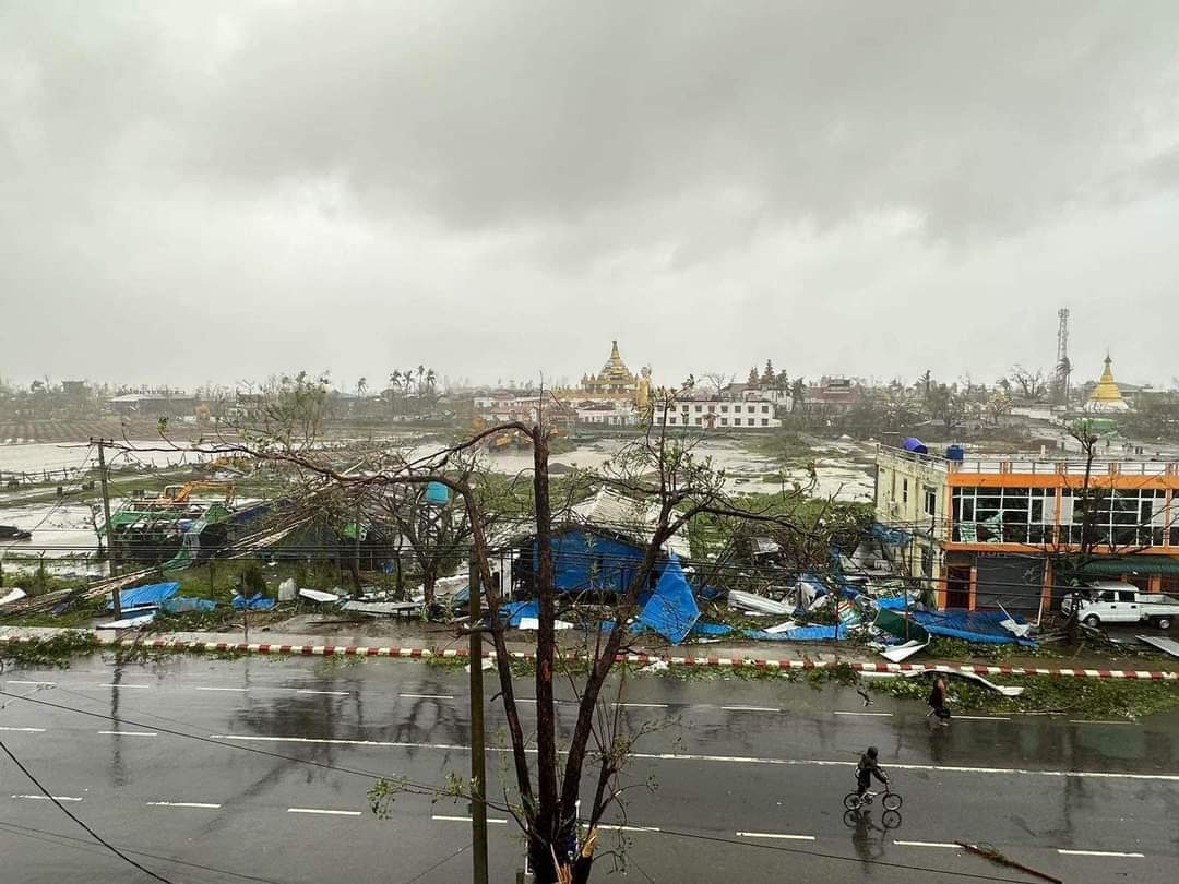
Damage caused by cyclone Mocha. (Twitter)
Storm observers say there is concern about intensifying cyclones in the NIO. Cyclones form in the NIO region during the pre-monsoon (March–May) period, and even more during the post-monsoon (October-December) season.
Most extremely severe cyclones in the NIO appear to occur during May.
Over the past five years, four extremely severe cyclones have been reported in the region in May.
Mekunnu hit Oman in 2018. Fani hit Odisha in 2019, in the worst event since the super-cyclone two decades earlier. Amphan made landfall in West Bengal in 2020, and Tauktae made it in Gujarat in 2021.
May is the time when the maximum intensity that a storm can reach — called potential intensity — peaks, notes a 2022 study by a team at the Indian Institute of Tropical Meteorology (IITM), Pune.
This rise is influenced largely by the rise in the sea surface temperature, the IITM study led by Swapna Panickal noted.
Besides the cooling of the tropopause — the boundary between the dry stratosphere (up to 6 – 17 km above the earth) and the more meteorologically active layer below — due to carbon emission contributes to this rise.
So does the weakening of the summer monsoon, the IITM team noted. This weakening reduces the vertical wind shear, or the change of horizontal wind direction and/or speed with height, and southward ocean heat transport and enhances heat accumulation in the ocean.
At the same time, ACARR studies show a rise in intense cyclones during the October–December period as well. The Arabian Sea is becoming prone to more intense storms.
NIO witnessed five cyclones per year with one to two events in the Arabian Sea a decade ago, while the global annual mean remained at 85.
“Our studies show that amidst increasing tropical cyclone activity, post-monsoon (October–December) events are gaining intensity,” Abhilash said.
The first recorded post-monsoon extremely severe cyclone of the Arabian Sea occurred in October 2014 (Cyclone Nilofar), followed by two back-to-back extremely severe cyclones in 2015 (Chapala and Megh).
Satellite view of cyclone Maha and cyclone Kyar. (Twitter)
Among the five events in 2019, extremely severe cyclone Maha coexisted briefly with the super cyclonic storm (222 kmph and above) Kyar as an unprecedented double event in the satellite era of 1961–2018.
Meanwhile, the total duration of Very Severe Cyclonic Storms (119–221 kmph) has also increased three-fold.
“More severe cyclones are caused by the tropical cyclone heat potential that is excess heat in the ocean over the 26 °C isotherm, or the map connecting points having the same temperature,” Abhilash explained.
“It influences the genesis, severity, and duration of storms.”
Scientists see a possibility of potential intensity further increase over the NIO more than in the global tropics by the end of the 21st century, further driving extremely severe cyclones.
“Given the population density on our coasts, this trend has important implications for forecasting disaster risk reduction, and climate change adaptation,” Abhilash said.
Storm surges involving giant waves and coastal flooding caused by these extreme events can lead to enormous losses of lives and property along coastal regions.
“Indian Ocean region is densely populated, and climate change is intensifying storms. Their impacts last long,” said Dr Unni Krishnan, the Global Humanitarian Director of Plan International.
He called for “lifesaving and protection measures and to keep in mind the needs of vulnerable and displaced such as children, especially girls”.
