Published Aug 08, 2023 | 10:00 AM ⚊ Updated Aug 08, 2023 | 10:00 AM

")
Clouds over South India as of 4 pm on 7 August. (IMD)

With an El Niño alert in place, and the Indian Ocean Dipole (IOD) that can offset its rain-reducing effects by staying neutral, the Southwest Monsoon will remain weak, possibly for two more weeks. It raises concerns about dry and hot weather in parts of South India, especially the west coast.
“Monsoon is now in a weak phase, and models are suggesting it will extend for two weeks. It could be the impact of El Niño,” said Madhavan Nair Rajeevan, a monsoon expert at the National Centre for Earth Science Studies in Thiruvananthapuram.
Historically, El Niño years have brought June-August dryness and droughts across India. The India Meteorological Department (IMD), however, has assured that the influence of the IOD will nullify the effects of El Niño.
Surface warming of the central and eastern tropical Pacific Ocean, called El Niño, alternates with a cool phase called La Niña. Along with the large-scale, east-west oscillations in air pressure they cause, El Niño/La Niña Southern Oscillation (ENSO), which influences global weather.
IOD denotes the difference in sea surface temperature between the western and eastern Indian Ocean.
During a positive phase associated with good rains over India, warm waters enter the western parts, including the Arabian Sea, while cold deep waters are brought up to the surface in the eastern part. This pattern is reversed during the negative phase.
“ENSO outlook remains at El Niño Alert,” noted an Australian Bureau of Meteorology long-range forecast reflecting known impacts from significant climate drivers on 3 August.
“In the past, when we have reached El Niño Alert, events have subsequently developed around 70% of the time. Central and eastern Pacific sea surface temperatures (SSTs) are exceeding El Niño thresholds… IOD is currently neutral.”
However, wind, cloud and broad-scale pressure patterns continue to reflect an ENSO-neutral state, the bureau noted.
“The last strong El Niño was in 2016 and that was a large rain-deficit year for Kerala,” said Abhilash, director of the Advanced Centre for Atmospheric Radar Research, Cochin University of Science and Technology (CUSAT).
“SST over the eastern Pacific is almost touching an El Niño-like situation. If El Niño becomes stronger it is going to be a similar situation to 2016,” he told South First.
“It was the worst and most extreme drought year in Kerala in the recent past, an effect of climate change and variability,” a CUSAT study led by Abhilash noted.
The study, based on data from 1901 to 2016, raised concerns about declining rainfall in Kerala.
“It is found that southwest monsoon rainfall over Kerala is decreasing… during recent decades, whereas the post-monsoon rainfall is found to be increasing especially over south Kerala. There exists a weak relationship between Pacific SST and Kerala rainfall,” he said.
CUSAT scientists showed rainfall becoming less over time.
Abhilash is sceptical about the potential effect of IOD in bringing back the rains. As such IOD effects are not coming into play till September, as the Australian long range-forecast shows.
Rain observers are keenly looking at yet another weather phenomenon called the Madden-Julian Oscillation (MJO). MJO is a weather system involving clouds, rainfall, winds, and pressure that traverses the tropics, influencing the monsoon.
Overall, there tends to be weak or absent MJO activity during moderate or strong El Niño episodes, scientists said.
“Currently it is weak and looks like it is coming to the Indian Ocean region next week. So there are chances of rain. But its activity depends on the amplitude of the MJO,” said Abhilash.
Most climate models surveyed by the Australian Bureau indicate no significant strengthening of the MJO in the next two weeks. In effect, it means dry conditions.
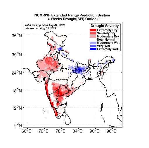
A National Centre for Medium-Range Weather Forecasting weather map issued earlier this week shows that much of Kerala and the west coast are likely to experience extremely dry conditions (please see map). Still, scientists do not rule out the possibility of one-off heavy rain events.
Monsoon has a strong seasonality, but heavy rains are often driven by local dynamics and phenomena lasting only for a short time within the season.
Weak monsoon rains are increasing local temperatures. “If wind is not present we will be getting hot weather like we get during the summer,” Abhilash said.
The high humidity of the season makes it all the more uncomfortable with the high heat index, a measure that combines air temperature and relative humidity.
“Monsoon winds are very weak, and they play a key role during the season,” he added.
