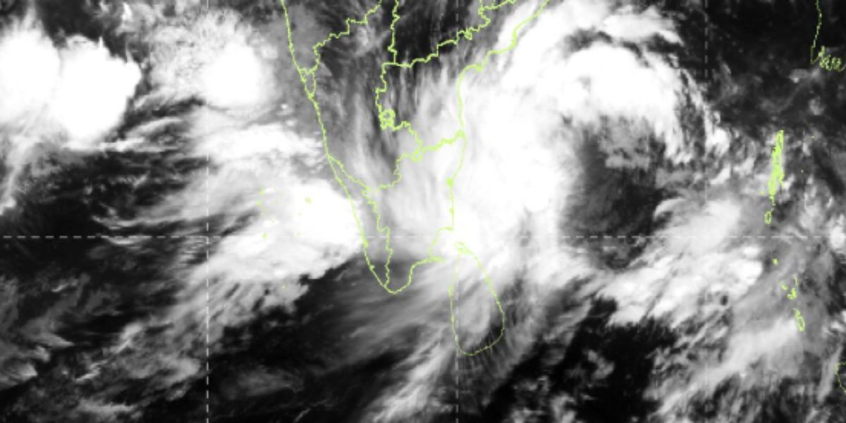
The cyclone is expected to intensify into a severe cyclonic storm by Tuesday morning while moving in a west-northwesterly direction.
Published Oct 27, 2025 | 9:32 AM ⚊ Updated Oct 27, 2025 | 5:08 PM

As of 6 am on Monday, the system was centred approximately 600 km east of Chennai, 710 km south-southeast of Visakhapatnam, and 680 km south-southeast of Kakinada.
Synopsis: The IMD said that the deep depression over the southwest and west-central Bay of Bengal has intensified into Cyclone ‘Montha’. The Andhra Pradesh State Disaster Management Authority said it is continuously monitoring the situation and advised citizens to follow official updates and refrain from believing or spreading unverified information.
The India Meteorological Department (IMD) said on Monday, 27 October, that the deep depression over the southwest and west-central Bay of Bengal has intensified into Cyclone ‘Montha’, moving northwestward at a speed of 18 kmph since 3 am.
As of 6 am on Monday, the system was centred approximately 600 km east of Chennai, 710 km south-southeast of Visakhapatnam, and 680 km south-southeast of Kakinada.
The cyclone is expected to intensify into a severe cyclonic storm by Tuesday morning while moving in a west-northwesterly direction.
The Andhra Pradesh State Disaster Management Authority (APSDMA) said it is continuously monitoring the situation and advised citizens to follow official updates and refrain from believing or spreading unverified information.
The IMD said, along the coast, squally winds with speeds of 90–110 kmph are likely during the next 24–36 hours. Heavy to very heavy rainfall is expected in the districts of Kakinada, Konaseema, West Godavari, Krishna, Bapatla, Prakasam, and Nellore of Andhra Pradesh on Monday.
Heavy rainfall is also likely in Srikakulam, Vizianagaram, Alluri Sitarama Raju, Parvathipuram Manyam, Visakhapatnam, and Anakapalli districts. East Godavari, Eluru, NTR, Guntur, Palnadu, Chittoor, and Tirupati districts are also likely to receive heavy rainfall.
The APSDMA said while weather conditions may appear calm in some areas, people are advised not to be complacent. “Remain alert and stay indoors in safe shelters as the cyclone approaches,” it said in a press release.
According to the IMD, the cyclonic system is likely to cross the Andhra Pradesh coast between Machilipatnam and Kalingapatnam around Kakinada during the evening/night of Tuesday as a severe cyclonic storm with a maximum sustained wind speed of 90-100 kmph gusting to 110 kmph.
The weather agency further warned storm surge of a height of about one meter above the astronomical tide is likely to cause inundation over low-lying areas of coastal Andhra Pradesh and Yanam (Puducherry), around the landfall time.
Citizens are advised to contact emergency helpline numbers (112 | 1070 | 1800 425 0101) in case of emergencies.
Later on Monday, Chief Minister N Chandrababu Naidu directed the officials to be more alert and shift the people of coastal areas to rehabilitation centres and distribute 25 kgs of rice and essential commodities.
He further said that top priority should be given to provide cyclone information to people in real time by releasing weather bulletins every hour, and asked the officials to see that there should not be any interruption to communication system and satellite phones should be used.
Naidu also informed that Prime Minister Narendra Modi called him over phone and enquired about the intensity of cyclone and he explained about the precautionary and relief measures taken up by the state government. He said that the prime minister assured necessary help from the centre and entrusted the responsibility of coordination with Prime Minister’s office to Minister Nara Lokesh.
The chief minister also reviewed the cyclone situation from RTGS center at secretariat and discussed with officials over precautionary and relief measures.
He noted that Krishna district is likely to receive heavy rainfall due to cyclone on Tuesday, 28 October morning, and Guntur, Bapatla, NTR, Palnadu and West Godavari districts are also likely to receive heavy rainfall as the cyclone is likely to cross the coast Tuesday night.
Naidu further stated that all the fishermen who ventured into sea were brought back.
He said that the NDRF, Panchayati Raj Engineering Department, Roads and Buildings Department, and Electrical Department officials should be prepared for restoration operations after the cyclone.
The officials stated that 851 JCBs and 757 power saws have been kept ready. The Chief Minister directed that there should be proper mapping of cyclone relief equipment.
He further instructed the officials to focus on alerting people and advising them not to venture out during the cyclone. He emphasized the need to take all necessary precautionary measures to prevent the loss of life and property. The Chief Minister also warned that strict action would be taken against those who fail to perform their duties during the cyclone crisis.
