Published Aug 07, 2024 | 12:00 PM ⚊ Updated Aug 07, 2024 | 12:00 PM

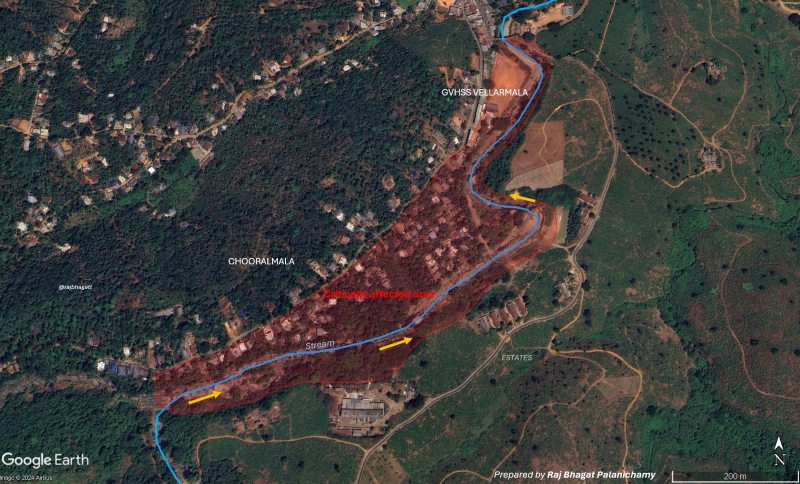
Areas affected in Chooralmala, Vellarmala areas. (Supplied)
The landslides that struck Wayanad a week ago resulted in the severe loss of lives and properties. Authorities are still sifting through the debris, looking for possible survivors, but ending up finding bodies, and body parts.
Even as Kerala is yet to recover from the shock of the worst-ever natural disaster it faced in a century, as a civilised society, the series of events that triggered the landslide, and the way forward should be looked at to avoid such disasters in the future.
The Chaliyar river system is a west-flowing group of rivers originating in the Western Ghats in Kerala.
Some of its tributaries bubble up at more than 2,000 metres above sea level and through the erosion of the ghats, they formed deeper valleys and then drained into the Arabian Sea near Beypore in Kozhikode.
There are numerous waterfalls in the multiple streams because of this landscape. The Iruvazhinijipuzha River along which the landslide happened is one of the tributaries of the Chaliyar.
The map above shows the river system and the terrain through which it flows.
Zoom into the point where the landslides happened in the villages of Mundakkai, Chooralmala, and Vellarmala of Wayanad. The river here flows down a very steep terrain.
The Iruvazhinjipuzha originates at an elevation of 2,000m above the mean sea level and heads towards the riparian villages, Mundakkai, and Chooralmala.
The Vellarmala school can also be seen in this map. It is to be noted that the upstream of the rivers are largely natural landscapes with forests.
Plantations form the landscape in and around the villages. This elevated natural landscape and plantation far away from urban areas, evolved it into a sought-after tourist destination.
The Iruvazhinjipuzha drops steeply to Mundakkai, which is roughly at 1,040 metres above sea level and Chooralmala which is around 850 metres above sea level.
This rapid fall happens at a distance of just five kilometres (aerially). The steep slope can be seen in the profile map.
Steep slopes such as this in an area which has a high probability of extreme rainfall are vulnerable to landslides.
Based on the heavy rainfall, slope, and drainage patterns, multiple landslide susceptibility maps have been created across the globe.
The map (left, below) shows the landslide susceptibility in Kerala based on an analysis by NASA. One can notice that the slopes of the Western Ghats passing through the eastern parts of Kerala, which include districts such as Wayanad, and Idukki — much vulnerable to landslides.
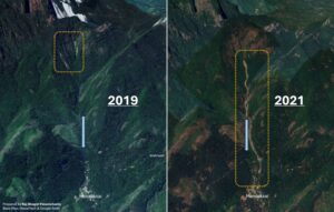
Due to this setting, landslides were reported in the area earlier also. There was a landslide in 2020 that removed a significant amount of vegetation in the path of the river and exposed a lot of topsoil and riverbed to further erosion.
Since the vegetation had not regenerated, the river became extremely vulnerable to landslides.
In the satellite images from 2019 and 2021, which were before and after the 2020 landslides, clearly shows the region exposed in 2021.
The southwest monsoon 2024 has so far been bountiful for the region. This meant that the soil in the region had a good amount of moisture.
On 29 and 30 July, when an extreme rainfall event (above 500 mm) hammered the region, the damp soil exposed by the previous landslide failed. And it led to the series of landslides on 30 July.
Based on satellite images, a few interpretations are possible.
First, two distinct crowns (top) were observed, which means that the landslide itself was a two-part landslide. The initial landslide might have removed a significant portion of the vegetation and would have hit the upper reaches.
As it cleared the vegetation and other obstacles, it would have helped trigger the second landslide which would have had high energy and more devastating than the first as the path was cleared for its movement.
Second, it is also clear from satellite images that the landslide is a reactivation of the older landslide from 2020. The map shows the areas that have been affected by the landslide.
Unfortunately, the toe (bottom) of the landslide was in inhabited areas. Since there were no buffers next to the river, and buildings were close to the stream, they were severely affected. Many of them were destroyed and some of them were partly damaged.
Though the landslide event itself appears to be natural, the damage could have been reduced if building regulations existed and the building construction were avoided along the river edges.
These buildings, with a few of them being villas aimed at tourists visiting the scenic location, were flattened.
Google Earth Image shows some of the areas that have been impacted and buildings. Due to the presence of big settlements, the death toll has been considerably high.
The preliminary analysis done using satellite images and other datasets indicated that the trigger for the landslide was natural.

Satellite images showing previous landslide along the stream in 2020. (Supplied)
However, the damage has been severely aggravated due to the extensive development in the region. It is important to note that there were no weather forecasts or warnings for extreme rainfall. In my opinion, short-term forecasts don’t work the way we imagine it to be.
Even if a red alert had been issued for the entire district, the disaster would have panned out in almost the same way. Due of the lack of spatial and temporal granularity in our forecasts which don’t have high precision, it would be difficult for us to identify vulnerable spots in a rapid manner.
There is also a lack of data at a granular level to study, and systems to monitor our landscape that would help identifying vulnerable areas. It is unlikely that our forecast systems would improve in a rapid manner over the next few years for us to precisely predict rainfall or rainfall associated events such as floods and landslides.
It is hence important for us to look at the long term with strategic plans and roadmaps.
Here is a list of what we should be doing in the near future for us to be better prepared. Though there are high-level technocratic reports on the vulnerability as well as recommendations for the region considering the ecological sensitivities, most reports don’t provide alternatives for answering the socio-economic aspirations of the people in the region.
Restrictions or regulations which are imposed without alternative pathways would end in failure. Hence at a regional level, a strategic development plan must be developed. This development plan prepared with the involvement of all stakeholders in the region should consider both environmental and economical aspects.
Based on the regional developmental plan, a detailed masterplan should be drawn up, incorporating zoning regulations with scientifically prepared hazard maps and vulnerability assessments. It should provide the details on where to build, what to build, and how to build.
The development of these master plans and regional plans can’t be top-down and autocratic in nature. Though external experts can be consulted, it is imperative that local academic institutions under the guidance of the local governance and planning agencies should be roped in to study, monitor, and prepare the plans for the region.
Though these idealistic solutions have been proposed many times in the past, they have failed to take off as there are lots of ground realities that affect the execution of the same. It is not possible to balance environmental considerations and economic aspirations overnight with blanket bans and regulation frameworks.
Hence, the first step should be to prepare a detailed road map for the region, setting goals and deadlines to address the ground realities and provide a pragmatic way forward for the region.
If we can come up with this road map over the next few weeks or months for ecologically sensitive regions such as Idukki, Wayanad, and other parts of Kerala, it is possible for us to avoid such disasters in the future.
(Raj Bhagat Palanichamy is a GeoAnalytics expert working in the field of data-driven decision-making for urban development, water resources, and environment. Views are personal. Edited by Majnu Babu)
(South First is now on WhatsApp and Telegram)

